Draft of new map page: Difference between revisions
Aubergine10 (talk | contribs) (draft) |
Aubergine10 (talk | contribs) (draft) |
||
| Line 1: | Line 1: | ||
intro text | (intro text) | ||
== City overview map == | == City overview map == | ||
| Line 5: | Line 5: | ||
This map shows a single city and it's buildings: | This map shows a single city and it's buildings: | ||
pic | (pic) | ||
From here you can interact with your existing buildings (by clicking on them) or make new buildings at the Senate. As you build up your city, you'll see new buildings appearing and existing buildings getting bigger and more advanced. | From here you can interact with your existing buildings (by clicking on them) or make new buildings at the Senate. As you build up your city, you'll see new buildings appearing and existing buildings getting bigger and more advanced. | ||
| Line 17: | Line 17: | ||
The mini map is visible at all times and shows the island where your currently selected city is located: | The mini map is visible at all times and shows the island where your currently selected city is located: | ||
pic | (pic) | ||
Clicking the mini map will instantly take you to the [[#Island map|Island map], centred on the island where your current city is located. | Clicking the mini map will instantly take you to the [[#Island map|Island map]], centred on the island where your current city is located. | ||
Tip: Your current city is shown as a yellow-ish dot on the mini map. | |||
== Island map == | == Island map == | ||
=== What's that weird pointy circle thing? === | === What's that weird pointy circle thing? === | ||
| Line 30: | Line 31: | ||
[[file:map-pointer.png]] | [[file:map-pointer.png]] | ||
The circle (position indicator) shows where the mouse is on the map | The circle (position indicator) shows where the mouse is on the map. | ||
The pointer indicates which direction the currently selected player (that's you!) city is in relation to the position indicator. It will always point at your currently selected, unless the position indicator is placed over that city causing the pointer to disappear. | The pointer indicates which direction the currently selected player (that's you!) city is in relation to the position indicator. It will always point at your currently selected, unless the position indicator is placed over that city causing the pointer to disappear. | ||
| Line 38: | Line 39: | ||
[[file:map-city-info-panel.png]] | [[file:map-city-info-panel.png]] | ||
=== How long will it take my troops to get there? === | |||
The island map has a really useful feature that shows you the travel time of specific units from your currently selected city to any other location on the map. This is a great tool for planning attacks! | |||
[[file:map-travel-time.png]] | |||
First, click the little arrow button on the location panel and choose which units you'll be sending to that location. You can select multiple units from the list and the slowest one will determine the time. | |||
Next, hover the mouse over the map and you'll see the travel time appear next to the little ship icon in the location panel telling you the time it will take for the selected units (those with red boxes around them) to get to that location on the map. | |||
=== How do I display another player's city on the map? === | === How do I display another player's city on the map? === | ||
The Grepolis world is huge, it could take you literally weeks to find a specific city simply be scrolling around the map. Luckily there's several ways to locate any city in the Grepolis world... | |||
If you know the X,Y coordinates of the city, enter them in the location panel and click the arrow to jump to the city: | |||
(pic) | |||
You can also jump to a city from the list shown on a player profile by clicking the "Center the map" button next to the city name: | |||
(pic) | |||
=== What do the different flags mean? === | |||
Each city and farming village has a little flag next to it on the map which indicates: | |||
* Alliance coat of arms (the image on the flag) | |||
* Colour indicating your relationship with the alliance or player | |||
== Ocean map == | == Ocean map == | ||
Revision as of 01:35, 17 March 2011
(intro text)
City overview map
This map shows a single city and it's buildings:
(pic)
From here you can interact with your existing buildings (by clicking on them) or make new buildings at the Senate. As you build up your city, you'll see new buildings appearing and existing buildings getting bigger and more advanced.
If you have multiple cities you can switch between them using the icons at the top of the screen.
(will put pic here once I have multiple cities!)
Mini map
The mini map is visible at all times and shows the island where your currently selected city is located:
(pic)
Clicking the mini map will instantly take you to the Island map, centred on the island where your current city is located.
Tip: Your current city is shown as a yellow-ish dot on the mini map.
Island map
What's that weird pointy circle thing?
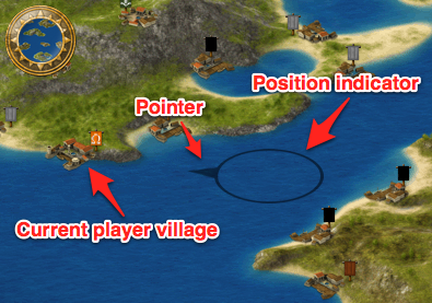
When you move the mouse over the map, a circle with an arrow on it will follow the mouse:
The circle (position indicator) shows where the mouse is on the map.
The pointer indicates which direction the currently selected player (that's you!) city is in relation to the position indicator. It will always point at your currently selected, unless the position indicator is placed over that city causing the pointer to disappear.
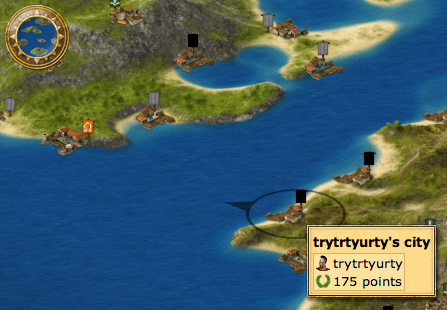
When the position indicator is placed over any player city or farming village, an info panel will appear giving brief details about it such as alliance (for cities) and mood (for farming villages).
How long will it take my troops to get there?
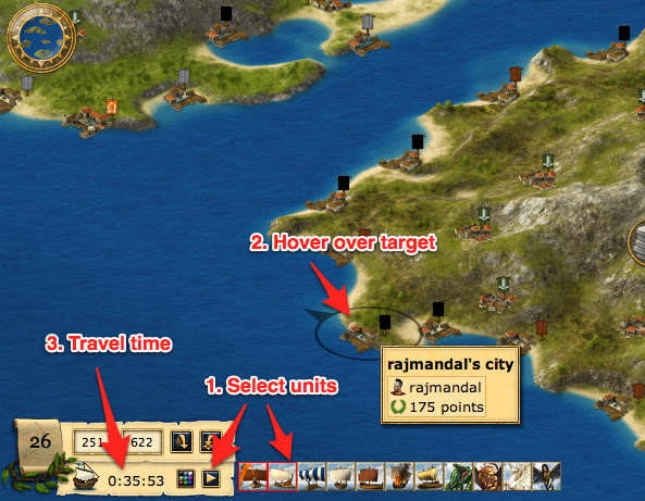
The island map has a really useful feature that shows you the travel time of specific units from your currently selected city to any other location on the map. This is a great tool for planning attacks!
First, click the little arrow button on the location panel and choose which units you'll be sending to that location. You can select multiple units from the list and the slowest one will determine the time.
Next, hover the mouse over the map and you'll see the travel time appear next to the little ship icon in the location panel telling you the time it will take for the selected units (those with red boxes around them) to get to that location on the map.
How do I display another player's city on the map?
The Grepolis world is huge, it could take you literally weeks to find a specific city simply be scrolling around the map. Luckily there's several ways to locate any city in the Grepolis world...
If you know the X,Y coordinates of the city, enter them in the location panel and click the arrow to jump to the city:
(pic)
You can also jump to a city from the list shown on a player profile by clicking the "Center the map" button next to the city name:
(pic)
What do the different flags mean?
Each city and farming village has a little flag next to it on the map which indicates:
- Alliance coat of arms (the image on the flag)
- Colour indicating your relationship with the alliance or player


