Draft of new map page
This guide explains the 5 different map types that enable you to explore and dominate your Grepolis world...
Maps overview
There are 5 different zoom levels on a Grepolis world, click on the one you want to know more about:
| City Overview Map | Mini Map | Island Map | Ocean Map | World Map | ||||
|
|
|
|
| ||||
| Build, inspect and interact with your city and tech tree. | Your island and it's cities, links to the island map. | Explore islands, inspect cities & farming villages, launch attacks. | Explore the world, great for alliance/battle planning. | Shows where the current ocean map is in the world. |
In addition to the in-game maps, there are several external tools that can generate maps.
City Overview Map
The city overview map allows you to inspect one of your cities, create and upgrade buildings, and use the special features of each building:
Watch a quick intro on Youtube
How do I display the City Overview Map?
Click the "City Overview" link in the sidebar menu to display your current city:
(pic)
Map details
From here you can interact with your existing buildings (by clicking on them) or build/upgrade/demolish buildings at the Senate. As you build up your city, you'll see new buildings appearing and existing buildings getting bigger and more advanced.
How do I display a different city?
If you have multiple cities you can switch between them using the arrow icons at the top of the screen:
(pic)
Note: You can only view your own cities. If you want to sneak a peak in to other players' cities, you'll have to resort to Espionage.
Mini Map
The mini map is visible at all times and shows the island where your currently selected city (shown as a yellow-ish dot on the mini map) is located:

As you can see, the mini map also shows other players' cities that are nearby. The colours are explained in the next section about the Island map...
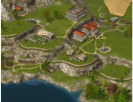
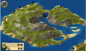
Island Map
When you click anywhere in the mini map, the Island map will be shown, centered on your island:

This is your primary view for investigating other cities, farming villages, and initiating attacks, support, espionage or trade missions. Before we do that, let's cover some of the basics...
What does the resource symbol in the middle mean?
Near the center of the island, you'll see a symbol indicating what the island's production bias is:
| Icon: | ||||||
| More: | Wood | Wood | Stone | Stone | Silver | Silver |
| Less: | Stone | Silver | Wood | Silver | Wood | Stone |
For example, the first icon shown above indicates that the island will have a wood production bonus (your timber camp will produce more wood per hour than usual) at the expense of stone (your quarry will produce less stone per hour than usual).
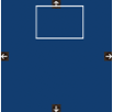
How do I scroll the map?
To move around the island map, simply drag it in any direction - just like you would on Google maps:

Note that if your mouse is over a city or farming village you won't be able to drag - it's best to hover the mouse over the sea or empty land on the island before dragging.
What's that weird pointy circle thing?
When you move the mouse over the map, a circle with an arrow on it will follow the mouse:

The circle (position indicator) shows where the mouse is on the map.
The pointer indicates where your currently selected city is in relation to the position indicator. When the position indicator is over that city, the arrow will disappear indicating that you're looking at your current city.
When the position indicator is placed over any player city or farming village, an info panel will appear giving brief details about it such as alliance (for cities) and mood (for farming villages).

How long will it take my troops to get there?
The island map has a really useful feature that shows you the travel time of specific units from your currently selected city to any other location on the map. This is a great tool for planning attacks!

First, click the little arrow button on the location panel and choose which units you'll be sending to that location. You can select multiple units from the list and the slowest one will determine the time.
Next, hover the mouse over the map and you'll see the travel time appear next to the little ship icon in the location panel telling you the time it will take for the selected units (those with red boxes around them) to get to that location on the map.
How do I display another player's city on the map?
The Grepolis world is huge, it could take you literally weeks to find a specific city simply be scrolling around the map. Luckily there's several ways to locate any city in the Grepolis world...
If you know the X,Y coordinates of the city, enter them in the location panel and click the arrow to jump to the city:

You can also jump to a city from the list shown on a player profile by clicking the "Center the map" button next to the city name:
(pic)
What do the different flags mean?
Each city and farming village has a little flag next to it on the map which indicates:
- Alliance coat of arms (the image on the flag)
- Colour indicating your relationship with the alliance or player
Farming villages always have the same coat of arms and flag colour:

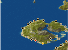
Ocean Map
The ocean map (also referred to as "world map") provides the most zoomed-out view in Grepolis, allowing you to explore the world and its oceans:

This view is useful for spotting allies and enemies in a given region, based on their city colours:

Tip: There are various awards available based on your dominance of an Ocean or the larger Grepolis world.
You can double-click any island to zoom in on it and view it's island map.
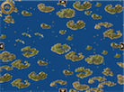
World Map
The World map is displayed to the right of the Ocean map and indicates which part of the larger world is being viewed in the Ocean map.

Awards
Each time you create or upgrade a building, your city will gain points. The points of all your cities contribute to your total points which in turn determines your ocean and world rankings. If you get enough points and high enough rankings you will get awards for your impressive civilisation size such as Point King, Ruler of the Seas and Ruler of the World.